Place and export
Placing
Section titled “Placing”A metes-and-bounds description defines shape, not location, so placement comes in three ways. All three behave the same in QGIS.
- PLSS aliquot tracts already know where they are, so the browser places them for you: they are on the map, georeferenced from BLM’s public survey fabric, by the time the result opens. The card’s place button reads Placed before you have touched it.
- Metes-and-bounds tracts take one click on the point of beginning. A live preview follows the cursor; adjust rotation if the deed’s bearing basis differs from grid north, then confirm.
- Composite conveyances, where two or more tracts tie to the same commencement monument, place together. One click on that monument puts every tract at the offset its own tie courses describe, and rotation turns the assembly as a unit.
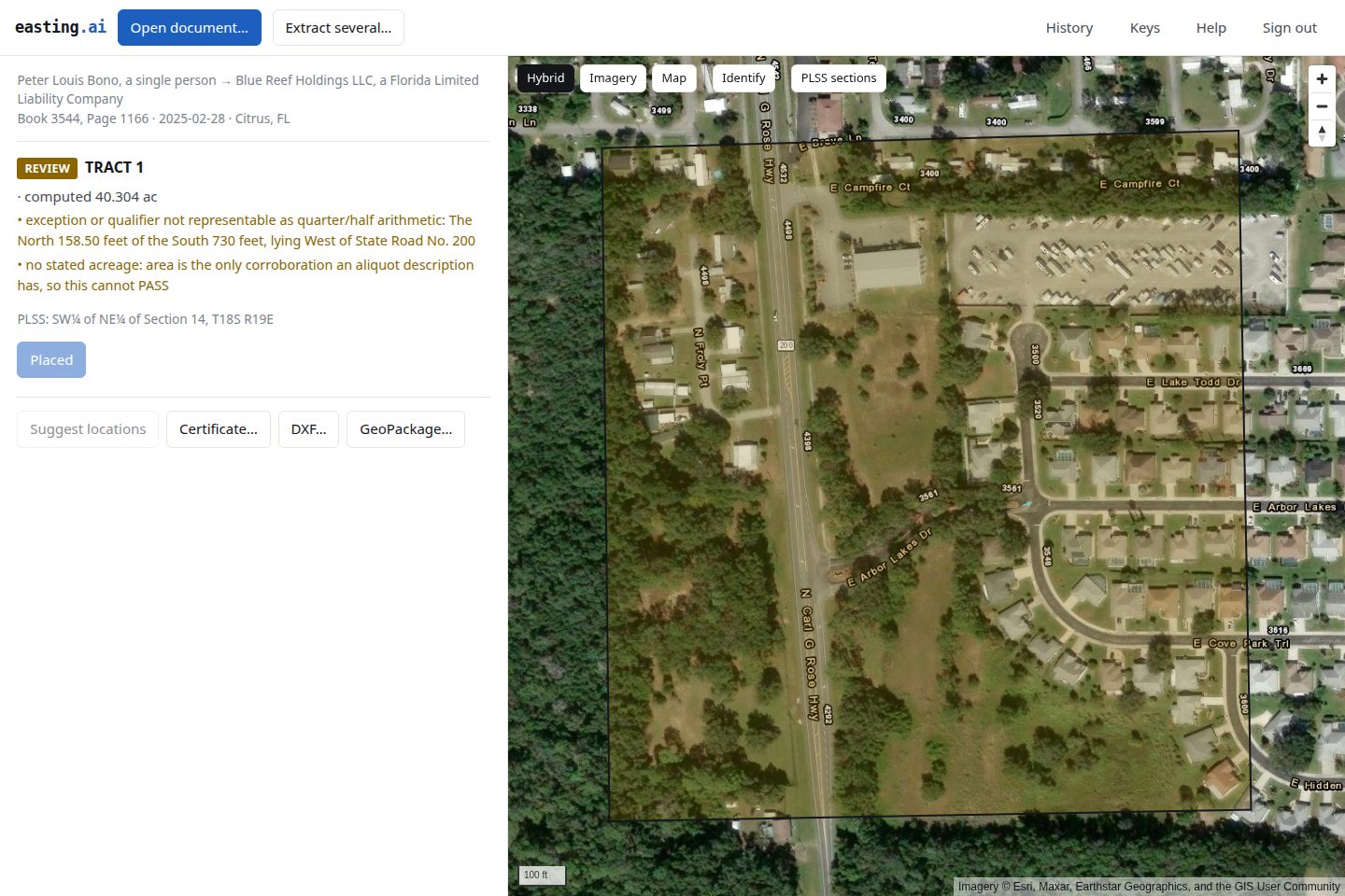
The browser handles projection itself, so the geographic-CRS warning QGIS shows never appears here.
Placement is remembered
Section titled “Placement is remembered”Confirming a placement saves it, so reopening that document from the runs list puts the tract back where you left it, rotation included. Positions are stored in latitude and longitude, so a deed placed in the browser opens in the same field in QGIS, and a deed placed in QGIS opens here.
The position is not part of the extraction and never enters the certificate. A verdict is the service’s claim about arithmetic it performed and can defend; where a parcel sits on the earth is your claim, from your knowledge of the ground, and signing it would put our attestation behind a judgement we never checked. Aliquot tracts store nothing, because the PLSS fabric places them again on every open.
The runs list shows how many tracts each run has placed, and Forget placement drops those positions while keeping the extraction. Deleting a result takes its positions with it.
Suggested locations
Section titled “Suggested locations”Suggest locations asks the service where a document’s tracts sit. It answers from a PLSS corner it can resolve, or from a boundary the deed shares with a parcel you have already placed, described from the other side. That second case fixes the rotation as well as the position, because two reciprocal courses pin the shape both ways.
A match is offered only when something corroborates it: the adjoiner text naming the neighbour’s grantor or grantee, or the next course round agreeing too. A matching length and bearing alone is a coincidence, and the parcels must also end up on opposite sides of the line they share.
Suggestions are previewed and never placed. They also improve as you work: the first deed in a county adjoins nothing, and the twelfth usually adjoins something.
Your fabric: every parcel at once
Section titled “Your fabric: every parcel at once”Download fabric, on the runs page, assembles every parcel the account has located into one WGS 84 GeoPackage: everything placed in the browser and everything placed in QGIS, on one map, however many documents they came from.
Two layers. parcels holds one polygon per located tract with its verdict,
closure, acreage, source document and run, and when it was placed.
parcel_boundaries holds each course with its bearing, distance, monument,
adjoiner and verbatim text, which is the part that makes the file useful for
chain work.
located_by says how each parcel got there, operator or plss, because a
position somebody chose and a position the survey fabric computed are
different kinds of claim.
Free and unmetered: the documents were paid for when they were extracted, and this is an arrangement of them.
Exporting
Section titled “Exporting”GeoPackage writes every placed tract as a polygon layer (verdict, closure, acreage, provenance) plus a per-call line layer (bearing, distance, confidence, verbatim text per segment).
DXF writes the traverse for a CAD operator. It arrives unplaced by design: point of beginning at the origin, distances in feet, because a deed describes a shape rather than a location and the basis is theirs to set. Curves come through as true arcs.
Certificate writes the GroundTruth Certificate of Digitization, the one-page artifact that goes in a project file.
Copy JSON puts the raw extraction on the clipboard for anything downstream.
Every one of these is byte for byte what the plugin and the API produce. The files are written by the service, not by the client that asked for them.
Finding a result again
Section titled “Finding a result again”The runs list answers “where did my result go”, which is otherwise a support email. It spans every key on the account, because a person owns keys rather than the other way round.
It resurrects nothing and says so: a result you have deleted stays in the list with its availability marked false. Dropping the row would answer the question with silence.
Every run in the list opens here, whichever key ran it. A deed extracted in QGIS this morning opens in the browser this afternoon, with the placement it was given there, because the account is the thing that owns work and the key is only how a particular program proves it belongs to you.
Deleting a result
Section titled “Deleting a result”Easting keeps every result until you delete it. Nothing expires on a clock.
Open History in the top bar to see every document the account has run, across all of its keys. Each row with a result held carries a Delete button, and Delete all results clears the whole account at once. Both ask before they act, and neither can be undone.
Deleting a run that came from a folder clears every document in that batch, because a batch is what you submitted and the history references it as one thing.
What survives a deletion is the record that the work happened: the document name, the date, and the verdict status stay in your history, because your invoice refers to them. What goes is the extraction itself, which is the part that quotes your document’s own words.